Showing posts with label Markha Valley. Show all posts

Wednesday, August 4, 2021

Ladakh | Markha Valley Route and Timings Update July 2021


Update- Though we did the trek from Skiu, the road now goes as far as Sara and possibly if the river is low as far as Markha. We therefore suggest that to drive from Leh to Sara on the first day (around 3 hours) and then walk after lunch to Markha. This will reduce one day from the trek and it will now become four to five days. Due to the pandemic the home stays were closed but it is possible to do this trek as a full home stay trek without tents and pony support once the covid situation eases up.

View of the peaks from Leh


Tuesday, August 14, 2018

Magic of the Markha | Trekking in Ladakh


There was no snow when I stepped on top of the Kongmaru La (5100 metres), the last pass on the Markha Valley trek. Below me was the steep trail which I had just ascended, zigzagging across the hillside. The long line of prayer flags danced crazily in the breeze while to the south-east, the snowy dome of Kangyatse peak (6400 metres) dominated the horizon.  To the north west, were a long range of mountains – the Karakoram? Could K2, the second highest peak in the world be amongst them, I wondered? The silence at the pass was soon shattered by the shrill neighing of the ponies and the cries of the pony men guiding their wards across this divide and down into the valley.

Six days ago, our team of six trekkers accompanied by the indomitable Stanzin and his crew had started out from Leh. The Markha Valley, wedged between the Stok Kangri range to the north and the Zanskar peaks to the south, is the most popular trek in Ladakh.


We left Leh on a sunny September morning with a hint of autumn in the air. The drive along the Indus and then along the Zanskar river to Chilling took around two hours. The crossing of the river at Chilling is an experience in itself which is not for the faint hearted as there is no bridge!   There is a trolley which holds three people at the most and is run by a winch which drags the trolley across the foaming Zanskar.

Once across the river, our ponies were waiting and with Stanzin, our guide, cook and “Man Friday” in the lead we set off for our trek. The days walk to Skiu was mostly on level ground and in about three hours we arrived at a spectacular campsite on the banks of the Markha river. The hot sun had been beating down on us for most of the afternoon so without much adieu we plunged into the icy waters for a well deserved bath!


The next day’s walk from Skiu to Markha is the longest – we passed a small lodge at Pendse which sells handicrafts made by the Ladakh Womens Alliance Group.  Just before Markha we crested a small pass with a fantastic array of chortens and yak horns.

That night at Markha we were rewarded by one of the most wondrous night skies. With my camera on a tripod I waited for the stars.  The last light of the setting sun faded from the sky and then the shadows of the night took over. Sirius, the brightest star in the sky shone like a beacon while higher up overhead was the Great Bear.


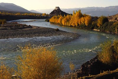
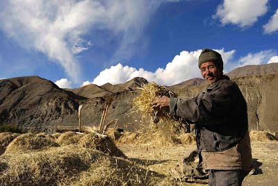
Fifteen minutes uphill from the Markha campsite lies the Markha gompa. The view from the monastery reveals a series of terraced fields in neat checker-board patterns above the river.  The villagers are able to grow one crop in summer and we saw ripened barley ready to be harvested.

The walk to Hankar the following morning took us past the impossibly high Tacha monastery clinging to a cliff which seemed more like a mountaineering challenge than a walk – we decided not to attempt the climb!


Stanzin proposed that we camp the next day near a small lake rather than continue to Nimaling. The lake camp below Kangyatse peak is Markha valley’s best kept secret.  Our tents were pitched on the shores of the lake which is rich in birdlife. We spotted sandpipers, wagtails, redstarts, accentors, dippers and many other species. In the background, the peak of Kangyatse stands sentinel over this pristine location.  The evening ended with a superlative Chinese dinner of hot and sour soup, fried rice and mushrooms with vegetables all cooked by Stanzin:  this was possibly the most perfect campsite on the trail!


The walk to Nimaling is through meadows where we saw marmots and the Ladakh pica scurrying in and out of their burrows. The giant golden eagles were soaring with the thermals and we tried in vain to spot bharal (blue sheep) perched high up on seemingly inaccessible crags.  A sharp wind blew across the pastureland and at this altitude of 4,500 metres we felt that we were finally above the clouds.  Ridge after ridge of the Ladakh ranges were behind us now, the gnarled rocks lit up in extraordinary colours of red and russet.

A steady two hour climb from Nimaling the next morning brought our group to the top of the pass. This was followed by a knee cracking descent of more than a thousand metres all the way down to the campsite of Chukirmo!


The last day’s walk through a canyon follows the valley past neatly manicured villages, a school and finally to the road head at Shang Sumdo. A welcome tea tent served us a meal and chilled juice while we waited for our transport back to Leh.

 Sculpted canyons, fantastic rock formations, ancient villages, Buddhist gompas and above all, the snowy mountains, the Markha valley could well be the ideal short trek in the Himalaya!


For more information on our treks in the Himalaya do visit www.southcol.com and for photographs from the Himalaya do visit www.sujoydas.com

And for details on the best gear, equipment and national parks in 2020 do visit this link
https://www.theskateboarder.net/trekking/

Sunday, March 12, 2017

Markha Valley Trek | Photographs in Black and White

Storm clouds over the ramparts of Markha monastery
The Markha Valley is one of the most popular treks in Ladakh. It is relatively short, located close to Leh, the walking is mostly below 4000 metres with  night stops around 3500 metres and has the best of Ladakh thrown in: Sculpted canyons and fantastic rock formations, medieval villages,  Buddhist gompas and snow-peaks. When approached from Chilling there is only one pass to cross the Kongamaru La which comes on Day 8 of the trek by which time most trekkers are properly acclimatised. This is one of  South Col's favourite Ladakh treks. Here are some photographs from Leh and the Markha valley from our visit in the summer of 2016.

Leh palace and monastery

Entrance of Hemis monastery

Prayer flags on the trail in a village

A South Col trekker in the Markha valley

Part of the trail submerged in unseasonal rain

Night Markha campsite

Kangyatse peak at sunrise from Nimaling

For some of our other stories on the Markha do visit
http://sujoyrdas.blogspot.in/2014/02/the-markha-valley-trek-part-i.html

http://www.outlookindia.com/outlooktraveller/destinations/up-above-the-world-so-high/


Monday, September 26, 2016

Ladakh | After Dusk

Campsite on the first day of the Phyang to Hundar trek

Over the past few years in Ladakh,   I have been shooting a number of locations after dusk mostly using my tripod and sometimes with long time exposure. This post showcases some of the "after dusk" images.

Star trails over Mount Kangyatse

The Stok Kangri range and Leh town at dusk

Moonlight at Hanker on the Markha valley trek

Lamayuru monastery

The tea tents and campsite of Nimaling

For more photographs from Ladakh and Zanskar do visit

For our 2017 trek in Ladakh do visit

Wednesday, August 31, 2016

Ladakh Flora II

Many people assume that since Ladakh is a barren cold desert nothing grows there. However, if you do visit Ladakh during the summer months and trek in the mountains you will be greeted with a  variety of wild flowers of different colours and textures. This is the second post in the series of Ladakh flora. The first post can  be found at  http://sujoyrdas.blogspot.in/2016/08/ladakh-flora-i.html


For more posts from Ladakh do visit  http://sujoyrdas.blogspot.in/search/label/Ladakh

For photographs of Ladakh and Zanskar do visit  http://www.sujoydas.com/Ladakh-and-Zanskar

For treks in Ladakh do visit  http://www.southcol.com/treks-nepal/rumtse-to-tso-moriri/

Tuesday, August 16, 2016

Ladakh Flora I

Most people who have not been to Ladakh imagine it to be a barren wasteland devoid of vegetation and flowers. But in the summer months many of our Himalayan floral species bloom in this high altitude desert.  Some of the flora of Ladakh seen over different treks and expeditions mainly between the months of July to September are below in this two part post. The second part will follow soon.


Tuesday, August 9, 2016

Markha Valley Trek | Ladakh July 2016 - Route and Timings

Campsite at Markha below the monastery

South Col Expeditions trekked the Markha Valley from Chilling to Shang Sumdo in July 2016. The day wise route and timings along with altitude  is given below.

July 17th 2016 Leh to Chilling to Skiu
We left Leh around 8 am. The previous day it had been drizzling the whole day and this had helped in bringing down the temperatures. Leh had been very warm  for the last few days and the rain was most welcome. We followed the Leh Kargil highway to Nimu   which is the confluence of the Indus and the Zanskar.  After some photographs at the site we went down on the road to Chilling which is 28km away. The road contours along the Zanskar river and we reached Chilling by 9 45 am. The bridge across the Zanskar is broken so we had to cross once again by trolley. By the time we had all our equipment and team across it was 11 am. We started walking east and in about 45 minutes crested a small pass which was visible from the river. There is a new jeepable road between Chilling and Skui and we followed this for most of the way excepting using some short cuts which avoided the long bends of the road. In about an hour from the first pass we reached the entrance of the village of Kaya and walked further up through the village until we reached the river where we stopped for lunch around 1 30 pm. The sun was hot but clouds were gathering towards the west. We left our lunch spot around 2 pm and in another 45 minutes reached the campsites of Skui. Skui also has a number of home stays so it is now possible to do the Markha valley trek in season time without camping support. The camp was the same location as last time pitched near the river. As it was both sunny and warm I decided to go down to river and have a wash in the delicious cold water which was incredibly refreshing. The next day we have a long walk to Markha around 22 km.
Chilling to 1st pass 45 min; 1st pass to Kaya village 1 hour; Kaya village to Skiu campsites 1 hour
Leh 3500 metres 34 10 11 N 77 34 40E; Chilling 3183 metres 34 0 31 N 77 12 24E;
Skiu 3348 metres 33 58 44 N 77 16 18E
Chilling to Skiu 9.8 km  approx.

July 18 2016 Skiu to Markha
We left Skiu at around 7 25 am. We initially followed the jeepable road and in about 90 minutes reached the tea stop of Pendse. From here in about half an hour we found that the river had overrun the entire road and crossing was difficult without  getting into the water. Another French trekker who had crossed with difficulty helped our group by bringing big boulders and throwing them into the water to make a path. This crossing delayed us for around half an hour and we started off again around 10 am. By around 11 30 am we reached a tea tent which was Humarge and then set out for Sera village which was the lunch stop. Around noon a  rain shower with high winds hit us and descending to Sera we got totally soaked. Around 12 40 pm we entered the first tea tent of Sera and had our lunch along with some hot tea made by the owner. We left Sera around 1 10 pm and headed up the valley. The trail climbed in parts and around 2 30 pm passed a very pretty village with mustard fields in  bloom. From the village a climb of around 30 minutes brought us to some chortens on a ridge. The path then went down to the river bed and again climbed up to another small pass around 4 pm with chortens in three colours. At the end of this valley lay the camping grounds of Markha which we finally reached around 5 pm after wading through the fast flowing Markha river which had knee deep water.  It had been a long and tiring day and the most which we would walk during this trek.
Skiu to Pendse Tea Shop 1 hr 45 min to 2 hours; Pendse to Sera village 2 to 2.5 hours;  Sera village to chortens above Markha 2 to 2.5 hours; Chortens above Markha to camp ground 45 min to 1 hr
Markha 3760 metres 33 53 14 N 77 25 18E
Skiu to Markha 22.5 km.

July 19 2016 Markha to Hanker
We left Markha around 8 am and headed up for the monastery. The monastery has a beautiful view of the Markha valley. All the fields below were yellow and green with mustard flowers in full bloom. We descended to the valley and started walking due east following the river. In about 45 minutes we had to cross the river once again by wading across the water. The July rains for the past few days had caused the rivers to swell and walking across was no more a possibility. It had become very hot in the valley and in about an hour from our river crossing we reached  the  tea tents of Umlung. From Umlung the trail initially followed the river valley and then contoured around some mani walls and chortens from where finally Hanker could be seen. The final walk to the village took around an hour as there were sections which had to be carefully navigated near the river where the path was nonexistent and a slight lapse of concentration would send you into the water.
Markha to the river crossing 45 min to 1 hour; River Crossing to Umlung tea tents 45 min to 1 hour; Umlung to Mani wall above Hanker 1 hour; Mani wall above Hanker to Hanker Village 1 hour.
Hanker 3945 metres 33 50 13 N 77 30 6 E
Markha to Hanker 11 km

July 20 2016 Hanker to Lake Camp below Kangyatse
We left Hanker around 7 40 am and climbed out of the valley to immediately reach a line of chortens. The trail then contoured through cultivated fields of barley and mustard following the river. In about an hour it left the river and climbed up to a trail which crossed over a bridge and reached the tea tents of Taughutse in around two hours. From Taughutse the trail climbed out of the valley and continued upwards for around  two hours until it reached a small pass at around 4650 metres. It then passed a couple of mani walls to reach a small lake below Kangyatse peak. In July when we arrived there was a second lake below the first lake on the trail to Nimaling - this would probably dry out by September once the water in the Markha river goes down.
Hanker to Taughutse tea tents 2 hours; Taughutse to Lake Camp 2.5 to 3 hrs
Lake Camp  4660 metres 33 48 19 N 77 33 32 E
Hanker to Lake Camp 12 km

July 21 2016 Lake  Camp to Nimaling via the top route
The Lake Camp where South Col Expeditions makes a night stop on the Markha trek is not a regular stop for other groups. The reason is that it is hardly two hours from Nimaling, the base for crossing the Kongmaru La  around 5150 metres. However the location of the lake just below the peak of Kang Yatse makes this a superb campsite possibly the best on the entire trek. On this visit rather than do the conventional two hour walk along the valley to Nimaling I decided to climb another 300 metres or so to the grazing pastures below Kangyatse and then descend to Nimaling bypassing the valley route. We started late around 8 45 am and followed the trail from the lake due south towards Kangyatse. The trail then veered to the east and some cairns could be seen on top of a hill. We climbed to the top in around an hour. The meadows were simply  splendid  - yaks grazed on the lush green vegetation,  the ladakh pika or mouse hate scurried in and out of its burrow searching for food, overhead two lammergeiers soared with the thermals while a multitude of finches, redstarts and thrushes skimmed through the lush vegetation. On would imagine Ladakh to be arid and dry but not these meadows in summer above Nimaling. We came to a stream which ran below Kangyatse  and followed it gently upstream. Our altitude showed 4940 metres, almost 300 metres higher than Lake Camp. Across the valley we could see quite clearly the trail to the Kongmaru La. It was a sparkling July day with the temperatures around a comfortable 20 Celsius. A light wind blowing across the meadows helped to cool things down. We then walked in a north easterly direction towards Nimaling and started to descend from the pastures. In about half an hour we could see the tea tents of Nimaling below us and in another half hour we reached our camp site. For those of you who have some time and are on a camping trek, the Lake camp and the high route to Nimaling is greatly recommended.
Lake Camp to Nimaling via the high route 3 to 4 hours. However, there are no well trodden trails you need to follow the yak trails and navigate using the compass.
Nimaling 4731 metres 33 47 25 N  77 37 2 E
The distance we walked was around 7 km and we reached upto 4940 metres.

July 22nd 2016 Nimaling to Kongmaru la and down to Chukirmo
We left Nimaling around 6.45am. It was a cloudy morning and Kangyatse was floating above the clouds. We climbed steadily and in about an hour reached a meadow where a large number of Ladakh pika were scurrying in and out of their burrows. From here we could see the steep climb upto the top of the pass. In the meadows at an altitude of around 5000 metres there were some beautiful blue flowers flowering in the rocks. We reached the top of Kongmaru la around 9 30 am after numerous stops. The view to the north which is normally very expansive was under clouds and as we stood there a few flakes of snow started to fall. The descent from Kongmaru la was steep and for the first hour zigzagged around the hillside losing around 300 metres. It then entered the gorge of the river valley where the trail had been damaged due to floods. There were numerous ups and downs - climbing out of the river bed and onto the trail above the rocks and then down to the river bed again to avoid the landslide sections. This continued for about three  hours before the trail suddenly narrowed and we could see the tea tents of Chukirmo.
Nimaling to Kongmaru La  3 km  Kongmaru La to Chukirmo  8 km
Nimaling to Kongmaru La  2 to 3 hours
Kongmaru La to Chukirmo  4 to 5 hours
Kongmaru La  5250 metres 33 47 25 N 77 37 2 E
Chukirmo 4100 metres 33 49 29 N 77 39 7 E

July 23rd 2016 Chukirmo to Shang Sumdo to Leh
We left Chukirmo around 7.30 am and leaving the camp site had to come down to the river and follow the river bed once again. In half an hour we reached the village of Chogdo which had some nice homestays and some green camp grounds above the river which would be much nicer than Chukirmo. Stanzin mentioned that there could be a problem with water if we had used these camp spots.  The trail then continued down the valley for around two hours and we entered Shang Sumdo around 9.45 am. Our transport had come and we trundled back to Leh after paying the Hemis National Park fees. We were back in Leh by lunchtime looking forward to a hot bath and clean clothes.
Chukirmo to Chogdo 30 min to 45 min
Chogdo to Shang Sumdo  2 hours to 2.5 hours
Chukirmo to Shang Sumdo distance  13 km
Shang Sumdo 3550 metres 33 85 71 N  77 70 44E 

For  our earlier posts on the Markha do visit 
http://sujoyrdas.blogspot.in/2014/02/the-markha-valley-trek-part-i.html
http://sujoyrdas.blogspot.in/2014/03/the-markha-valley-trek-part-ii.html
http://sujoyrdas.blogspot.in/2014/03/the-markha-valley-trek-part-iii.html

Sunday, May 8, 2016

Markha Valley | Hindu Business Line Blink April 30th 2016

feature Image

The Markha Valley is one of the most popular treks in Ladakh. It is relatively short, located close to Leh, the walking is mostly below 4000 metres with  night stops around 3500 metres and has the best of Ladakh thrown in: Sculpted canyons and fantastic rock formations, medieval villages,  Buddhist gompas and snow-peaks. When approached from Chilling there is only one pass to cross the Kongamaru La which comes on Day 8 of the trek by which time most trekkers are properly acclimatised.  The photos below give a description of the trek which I wrote for Hindu Business Line Blink for the April 30th 2016 issue.

To read the article on line please visit http://www.thehindubusinessline.com/blink/cover/a-himalayan-trek-is-always-a-rewarding-escape-from-the-scorching-plains/article8532688.ece


To trek the Markha with us from July 15th to 24th 2016 do visit this link for all information  http://www.southcol.com/treks-nepal/the-markha-valley-trek/


Click on the photo to enlarge

Click on the photo to enlarge

Sunday, April 10, 2016

Markha Valley Trek | Ladakh | July 15th to 24th 2016


South Col Expeditions will once again be trekking the beautiful Markha Valley in Ladakh from July 15th to 24th 2016. The details and schedule of the trek is below:

Day 01 Delhi to Leh  
We take the  spectacular one hour flight over the Himalayas to Leh. Be prepared to sit on the left hand window seat for the best views. The rest of the day is spent acclimatizing in Leh.
Day 02 Acclimatization day in and around Leh
We take the opportunity to visit some of the splendid monasteries in and around Leh like Shey, Thikse, Hemis etc.
Day 03 Leh to Chilling by road and then walk to Skiu 3400m (4 hours)
We leave Leh in the morning after an early breakfast and then drive to Chilling in around  two and a half hours. We meet our pony man and support team in Chilling.  From Chilling we start our four hour walk to Skiu  and reach by later afternoon.
698212474__dsc0094
Day 04   Skiu to Tunespa 3600 m ( 4 hours)  
The trail is mostly flat following the Markha river. After around three hours the trail crosses a bridge and then traverses some steep slopes before entering the hamlet of Chaluk. From Chaluk there is a short walk to Tunespa which is small village with cultivated fields. 
 Day 05 Tunespa to Markha 3700 meters 3 hours and then Markha to Hankar 3900 metres 3 hours 
The trail from Tunespa climbs up to some chortens from where there is a good view of the valley. It continues to follow the river until it enters Markha where we have lunch. From Markha it is a gentle climb past Umlung to Hankar where we stop for the night.
Day 06  Hankar to Tahungtse 4150 metres 3 hours   and the  Tahungtse to the Tea Tent (lake) 3 hoursFrom Hankar the trail climbs to reach the walled pastures of Tahungtse. We stop for an early lunch here and then proceed after lunch to reach the small tarn with excellent mountain views. There is a small tea tent here in season for refreshments

 Day 07   Tea Tent to Nimaling ( 4720 meters) 2 hours uphill  
The  trail climbs to Nimaling which is a large valley where yaks, sheep and goats are grazed by the villagers of Markha. We do a short day to Nimaling as the next day has a pass crossing and a stiff downhill! It is beautiful campsite but can often be cold and windy!

Day 08 Nimaling to Kongmaru La 5100 meters 2 hours and then down to Chukirmo 4050 meters four hours
The trail then climbs to the pass of Kongmaru La from where there are good views over the Zanskar mountains and the peak of Kang Yaze. From the pass the trail drops steeply for about 1000 metres to the settlement of Chukirmo where we camp for the night.
520365407__dsc0030
Day 09  Chukirmo to Shang Sumdo 31/2 hours and then drive to Leh two hours
The trail continues to drop but more gradually now to  Chogdo and then passes a school and finally enters Shang Sumdo. We have our packed lunch in Shang Sumdo and then drive  back to Leh.
Day 10   Leh to Delhi
We can avail the morning flight from Leh to Delhi and be back in civilization in an hour!  In case you wish to stay on in Leh further please do inform us for hotel bookings and onward reservations.
For a detailed pdf of this trek please email sujoyrdas@gmail.com.

Sunday, August 16, 2015

Markha Valley Trek | Photos

Night skies and stars at the Markha campsite
The summer months are the season for Ladakh and the most popular trek is the Markha Valley. I have watched the Markha trek graduate from a camping only trek to a home stay trek and now there are multiple home stays in each village.  Meals are also available at the homestays so a small group of trekkers could do the  Markha trek  without camping support during season time.

This year  Markha has been in the news - there was a report in the newspapers last week that due to flash floods and rising rivers many foreign trekkers had to be evacuated from the valley by helicopter.

Hopefully the weather has now settled and the rivers will go down gradually allowing trekking to resume.

I last did the Markha in September 2013 and here are some photographs from that trek which should be of interest to all Ladakh visitors.

Crossing the river at Chilling

Tea tent in the season at Skiu

Looking east below the monastery of Markha

Typical Markha valley landscape on the trail to Hankar


Hankar village 

One of our group snoozing with Kang Yatse peak in the back ground


On the trail to Nimaling

The pass of Kongmaru la looking back at Kangyatse peak

Homestay kitchen at Chokdo the last day of our trek

My outfit South Col Expeditions runs trek to Ladakh and different parts of the Himalaya. For more details do visit www.southcol.com.

For more photographs and articles on the Markha Valley please visit the following  links

http://www.sujoyrdas.blogspot.in/2014/02/the-markha-valley-trek-part-i.html

http://sujoyrdas.blogspot.in/2014/03/the-markha-valley-trek-part-ii.html

http://www.sujoydas.com/Ladakh-and-Zanskar/The-Markha-Valley-Trek-Ladakh/

http://www.sujoydas.com/SujoyDas/Outlook-Traveller-The-Markha/i-w9JL6Fs/A


LinkWithin

Related Posts Plugin for WordPress, Blogger...