 |
| Nupu Sherpa who runs the lodge |

Monday, January 20, 2020
Kangchenjunga White House | Khambachen Nepal


Saturday, January 4, 2020
Ghandrung - Ghorepani - Poon Hill Trek | Updates December 2019

A South Col team trekked the Annapurna foothills in the last week of December 2019. Our route was Pokhara-Kande- Australian Camp- Pothana- Tolka- Landrung-Ghandrung- Tadapani- Ghorepani- Poon Hill- Banthanti-Ulleri-Hillay-Birethanti-Pokhara.
Some useful updates from the trek.
- The road from Pokhara to Nayapul and Birethanti has now been pushed up beyond Ulleri to lower Banthanti. Though we did not see any jeeps on the road we were told by the locals that the road is ready and jeeps can be hired from Pokhara to drive up to Banthanti. We fear that the road will reach Ghorepani in the next one/two years thereby ending another beautful trek. Many would not want to continue to climb or descend the 3280 steps.
Tuesday, December 24, 2019
Kangchenjunga North Base Camp Trek Pangpema | Route and Timings Part II
 |
| Jannu and Sobidonge at sunset from above Kangbachen |
For details of the first part of our journey do visit https://sujoyrdas.blogspot.com/2019/12/kangchenjung-north-base-camp-pangpema.html
This is the second and final part.
November 16 2019 Ghunsa to Kangbachen 11.5 km
We left Ghunsa at 7.30 am on a cold morning with the temperatures well below zero Celsius. Ghunsa must be one of the coldest places in the Himalaya with an altitude of only 3415 metres primarily due to the limited sunshine hours just five and a half hours in November. The trail travelled north past the hospital and in around 45 minutes reached a log bench with prayer flags. For most of the way the trail meandered through rhododendron forests which would be a riot of flowers in the spring season April - May. It then dropped to a landslide section in 15 minutes and then skirted the river. Looking up due east in about an hour and a half we could see the peak of Khabur above us. The trail then crossed a second landslide section in about 2 hours with a log bridge across a stream.
We left Ghunsa at 7.30 am on a cold morning with the temperatures well below zero Celsius. Ghunsa must be one of the coldest places in the Himalaya with an altitude of only 3415 metres primarily due to the limited sunshine hours just five and a half hours in November. The trail travelled north past the hospital and in around 45 minutes reached a log bench with prayer flags. For most of the way the trail meandered through rhododendron forests which would be a riot of flowers in the spring season April - May. It then dropped to a landslide section in 15 minutes and then skirted the river. Looking up due east in about an hour and a half we could see the peak of Khabur above us. The trail then crossed a second landslide section in about 2 hours with a log bridge across a stream.
Friday, December 13, 2019
Kangchenjunga North Base Camp Pangpema Trek | Route and Timings Part I

A South Col Team trekked the North Pangpema
Base Camp of Kangchenjunga in November 2019. The details of the trek with day
wise itinerary and timings are below.
HIGHLIGHTS
- The start of both the north base camp trek and south base camp trek had rough jeepable roads for fair weather use. For our detailed post of these roads do visit http://sujoyrdas.blogspot.com/2019/12/kangchenjunga-trek-nepal-north-and.html
- Lodges are available on the trek but these are basic below Ghunsa and also have few beds. In case you are a large group (8-10 persons) during season time April and October you may be better off camping. Above Ghunsa the quality of the lodges improve dramatically and is some of them you can get attached toilets. There are also many more lodges.
- Phone connectivity is there in some of the locations – only Nepal Telecom not Ncell.
- There is no wifi available on the route excepting at Ghunsa Hospital.
- The trekking numbers are also low – from the Kangchenjunga Conservation Area Project records for 2019 I found that the spring season March to May 2019 had 202 trekkers while the autumn season September until 20th November 2019 had 634 trekkers out of which October alone had 407 trekkers. In comparison the Everest route has around 45,000-50,000 trekkers in a year!
- The approach from Kathmandu is usually through Bhadrapur airport a 45 min flight and then a long drive from Bhadrapur to Taplejung. There is an airport at Suketar but the thrice a week Nepal Airlines flight is not very regular and is often cancelled.
- There has been a lot of changes in the routes mentioned in the guide books some due to landslides and some new trails being developed and the guide books need updation e.g. Lelep often mentioned as a night stop is not required to be visited any more there is a direct trail now to Sekathum so do not follow the guide books blindly.
Wednesday, December 4, 2019
Kangchenjunga Trek Nepal | North and South | Road Construction
 |
| The Kangchenjunga group including Jannnu on the left and Kabru in front seen from a ridge above Ilam on the drive to Taplejung |
We found that dirt track roads suitable for four wheel drive vehicles have been built on the approach to both treks north and south. These roads are fair weather - hence it is doubtful if during heavy rain in the monsoon months they would be clear for traffic. However, we were informed by our jeep drivers that from middle October to middle May these roads are operating and can be used by trekkers to shorten their treks by 2-3 days. The journey, of course, like most Nepal dirt track roads is bone rattling but it does shorten 2 days walking into a four hour jeep journey.
Sunday, November 24, 2019
Ladakh Summer 2019

South Col Expeditions did two treks in Ladakh this summer in the Shang Sumdo to Rumbak region.
For detailed itineraies and route planning please do visit
http://sujoyrdas.blogspot.com/2019/09/ladakh-shang-sumdo-to-rumbak-trek.html
http://sujoyrdas.blogspot.com/2019/08/ladakh-shang-sumdo-to-stok-across-shang.html
Here are some photos from our treks.


For more details on our treks and photo workshops do visit www.southcol.com
For more photos do visit www.sujoydas.com
Thursday, November 14, 2019
Short 3-5 day Treks in the Indian Himalaya
 |
| Stok Kangri range from the Delhi to Leh flight |
The popular trek crosses some high passes and then comes to Tso Kar Lake from where there is a motorable road to Leh. It is also possible to extend this trek further to Tso Moriri by adding three days to the trek. The route is Rumtse 4325m - Kyamar 4055m- Tisaling 4215m- Ponganagu 4500m-Tso Kar. The best season for this trek is July to August. You should acclimatise in Leh for two days before starting out and you need to carry full camping gear, tents and food.
 |
| The shores of Tso Kar lake, Ladakh |
This trek starts from Mcleodganj crosses the Indrahar Pass 4300 metres and then ends at Machetar which is a four hour drive from Chamba. The route is Mcleodganj 1650m-Triund 3000m- Lahesh Cave 3600m- Indrahar Pass 4300m- Laka Got 3850m- Chata Kuarsi 2200m-Machetar 1950m. The best season would be April-May and again September to November. You need to carry your own camping gear, tent and food.
Rupin Valley Himachal 5 days
The scenic Rupin valley is a very under trekked area which is a pity as it offers a lot in terms of fast flowing rivers, bird life, mountains and lush forests. The route is Netwar 1350m- Sewa 2025m- Jakhu 2600m- Camp below Rupin Pass 3500m- Rupin Pass 45400m- Kanda 3425m- Sangla 2675m. The best season would be April-May and again September to November. You should carry camping gear and food.

Tunganath and Chandrashila / Uttarakhand 3 days
This is probably the shortest and most popular of all the easy treks in the Garhwal but with a great view from the top. The route would be Ukhimath 1300m - Deoria Tal 2100m- Chopta 2900m- visit Tunganath 3685m and Chandrashila 3900m- Dugalbitta 2347m.
 |
| Late afternoon Sandakphu - Jannu and Kangchenjunga |
Though a jeepable road goes to Sandakphu it still remains a popular trek especially with first timers. It is possible to combine this with Phalut and make it a seven day trip. There are different route options but the most popular one is Manebanjan- Tumling-Jaubari-Gairibash-Kalapokhri-Bikebhanjan-Sandakphu-Rimbick. This is one of the few locations which has views of four of the five highest peaks in the world – Everest, Lhotse, Makalu and Kangchenjunga. . The best time would be March to May and again October to December. You can stay in the home stays/bungalows on the way.
Shang Sumdo to Stok Village Ladakh 4 days
This trail crosses two 4950 metres passes before descending into Stok village. The route is Leh-Shang Sumdo- Shang Phu- Gangpoche-Mankarmo-Stok. It walks in the shadow of Stok Kangri and the other peaks of the range like Golep Kangri, Matho Kangri, Pyramid etc. A good season is July to September but there may be many stream crossings in July - September would be better if you want to avoid the crossings. A detailed itinerary is here http://sujoyrdas.blogspot.com/2019/08/ladakh-shang-sumdo-to-stok-across-shang.html
For more information on trekking in the Himalaya do visit www.southcol.com
For my photographs on the Himalaya do visit www.sujoydas.com
Monday, November 4, 2019
Everest Reflections on the Solukhumbu | Photos Book Launch Kolkata

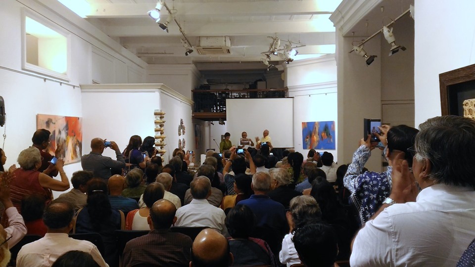
The book launch of Everest Reflections on the Solukhumbu was held at The Harrington Street Arts Centre on October 31st 2019.
Everest Reflections on the Solukhumbu, launched to celebrate the centenary of the birth of Sir Edmund Hillary and dedicated to the sherpas reveals the historical influences, hidden seasons and current pressures in the land of Everest. Photographer Sujoy Das and writer Lisa Choegyal have collaborated in their second volume, this time capturing the essence of the majestic scenery and reality of daily life in the Solukhumbu in the shadow of Mt. Everest. A foreword by leading mountaineer Sir Chris Bonington, preface by cultural scholar Dr Lhakpa Norbu Sherpa and drawings by artist Paula Sengupta adds depth to this unusual book about a familiar destination.
In the words of Sir Chris Bonington in his Foreword “This is not just one more book about Everest, but a special celebration of the haunting beauty of Solukhumbu and its people. Civilisation depends on the health of our high places, and I wish my Sherpa friends all the best with successfully navigating their future course.”
Sujoy Das, founder of South Col Expeditions which runs treks and photo workshops in the Himalaya www.southcol.com has spent more than two decades in the Everest region and is the co-author and photographer of a number of books including Nepal Himalaya A Journey Through Time, Sikkim A Travellers Guide and Lonely Planet Nepal for the Indian Traveller.
British-born Lisa Choegyal has made Kathmandu her home since 1974, deeply involved with Nepal tourism and conservation. Author and editor of Nepal Himalaya A Journey Through Time, Kathmandu Valley Style, The Nepal Scene Chronicles of Elizabeth Hawley and Offerings from Nepal, she produced the South Asian Insight Guides series, and contributes a fortnightly column to the Nepali Times.
Some photos and videos from the launch:



Subscribe to:
Posts (Atom)
LinkWithin
